|
|

Tidal Levels - General Description
 Researchers
over the years have tried to compare the various tidal levels on ocean
shores to create a system that can be used on any shore around the World.
Some researchers have used the varying lunar-month tidal levels, while
others have used indicator species to define the various levels.
Researchers
over the years have tried to compare the various tidal levels on ocean
shores to create a system that can be used on any shore around the World.
Some researchers have used the varying lunar-month tidal levels, while
others have used indicator species to define the various levels.
Some naming systems are very complex and use descriptions such as infralittoral, high midlittoral, high-water spring and high-water neap tides if the system is based upon the tides.
Littoral means tidal.
During a lunar month you will get a very high and a very low tide called the Spring Tide (this has nothing to do with the season Spring). A fortnight later there is a lower high tide and a corresponding higher low tide, called the Neap Tide.
Other researchers have based their system on the bands of fixed-location or sessile animals. They use categories such as the Upper Barnacle Zone, Lower Barnacle Zone, Cunjevoi Zone, etc.
This Seashore Life Web Site uses a generalised system based upon assumed tidal levels for any Australian shore.
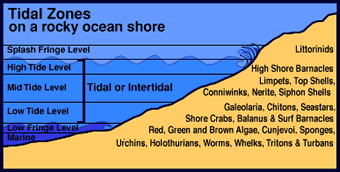
Splash Fringe Level
This is the level just above the highest tide level reached in any month. It may be wetted by spray and mist. On some wave-smashed rugged shores the Splash Fringe Level may extend a few hundred metres up a shore or up a cliff face. On very calm shores, this zone will not exist.
High-Tide Level
The upper part of the High-Tide Level is covered by the tide for only a few hours each day. Some creatures found here may only covered by water for a few hours each month. The dominant stationary animals are the high-shore barnacles. Below these are the semi-mobile molluscs, such as the limpets, siphon shells, chitons, top shells, conniwinks and the black nerite.
Mid-Tide Level
Along many south-eastern Australian shores, there is a characteristic band of hard, white, limy Galeolaria tube worms, which may form dense colonies. Many intertidal animals are adapted to living in the microhabitat provided by the thick tube-worm colonies. This level is covered and uncovered for about an equal time each tide cycle.
Low-Tide Level
This region, which often occupied by the sea-squirt Cunjevoi is uncovered for only a few hours each tidal cycle and is the favoured habitat of a large range of intertidal species.
Most species in this Web Site are found at this level, and include anemones, sea stars, sea urchins, chitons, tritons, whelks, limpets, barnacles and crabs. Some algal (seaweeds) species occur in moist gutters, crevices and in rock pools.
Low Fringe Level
Here, low tide oscillates around this level during the lunar month. At low tide this level is wetted and exposed during each wave. Most creatures and algae are fully marine and are not really adapted to spending some time exposed. Some carnivores move into the intertidal region to eat easily captured attached prey, such as barnacles, cunjevoi and slow-moving limpets. Most algal species live here.
Marine
Species found here are not adapted to spending any of their life cycle in the intertidal zone, except by accident. Some come in at high tide as predators of intertidal species. Many carnivorous fish and decapod crabs fit this category. A large range of algae are found here.
WebQuest Activity
Could all Questors consider the Major Question ?
What causes this obvious banded pattern to occur across a rocky shore?
Can this question can be divided into sub-questions on this topic?
- Do the different tidal levels on a shore provide a particular microhabitat which suits one type of species?
- What effect can the different tidal levels have on a species' range across a shore?
- What other factors in the environment associated with tidal levels might contribute to the banding pattern of organisms across a rocky shore?
Think of some other questions which may guide you in thinking about what facts you should be looking for.
Strategies:
Here are two strategies you may like to investigate.
1. In the first, Questors work alone, researching and exploring the information to produce a Project or a Report which may be written or spoken.
2. In the second, Questors split into groups of three. Each Questor might think about the information they find from various viewpoints.
- One may think of the information from an animal viewpoint.
- Another may think from a seaweed (algae) viewpoint, and
- the third Questor may think about the information from an environment viewpoint.
Tips:
- If you ask and write down good questions, this will assist you to find interesting and unusual answers.
- Spend about 10 - 15 minutes in thinking about the above questions, and write down some of you own questions as well.
- Look in the school and local library, the World Wide Web and some science, nature, biology and environmental CD-ROM's.
- Check out the resources links to look at the animals, seaweeds and their environment on seashores along the south-eastern shores of Australia.
- Report your findings back to the class. Write on the board a list of factors and reasons why animals and seaweeds in the intertidal zone might occur in bands across a rocky ocean shore.
- Visit the WebQuest Home Page and associated WebQuest resource sites for excellent problem-based learning materials.
Splash-Fringe
Level
The Tidal Zone
• High-Tide level
• Mid-Tide Level
• Low-Tide Level
Low fringe Level
Marine Zone
Home
Page
Taxonomy
Biogeography
Rocky Shores
Tidal Levels
Intertidal Zonation
Environmental Factors
Biological
Factors
Feeding Relationships
Activities
Glossary
References
 Life
on Australian Seashores
Life
on Australian Seashores
by Keith Davey (C) 2000
Learning Consultant
- Media
The University of Newcastle
email at australian_seashores@hotmail.com
Scientific Consultant: Phil
Colman
site created 01.01.98 : updated 01.04.2000