Home | About MESA | Contact MESA | Seaweek | Site Resources | Marine Links | International News | MESA History
  Habitats - The Southern Ocean    

Come on a journey across the vast Southern Ocean

Macquarie Island - scientists, sealers and shipwrecks

As explorers and whalers had done in past centuries, we stopped on the sub-Antarctic islands and witnessed these platforms in the southern ocean, brimming with life.

Four days after leaving Hobart we arrived at Macquarie Island, shrouded in mist and low cloud. Macquarie Island is situated 1500 km south-south-east of Tasmania. It is about half way between Tasmania and Antarctica at a latitude of 55 degrees south. Famous for its geology, Macquarie Island is a rare uplifted portion of the seabed at the edge of two tectonic plates. It was declared a World Heritage Area in 1997.

Click to enlarge
(Click to enlarge)
Southern Ocean

Click to enlarge
(Click to enlarge)

See left picture Here you can see how the island began as a spreading ridge on the ocean floor. It is estimated that this happened between 30 million and 11 million years ago. This is where basalt magma from deep within the earth flowed up to the ocean floor and out through long fissures or vents, forming new ocean crust.

See right picture About 10 million years ago this ridge stopped spreading. Instead of moving apart, the area on either side of the ridge started to squeeze together forcing the oceanic crust and parts of the upper mantle, upwards. About 600-700 thousand years ago Macquarie Island started its 2.5 km rise to emerge above the sea surface .

You can see how deep the trenches are on either side of Macquarie Island and how only the tiniest bit of land is exposed above the water.

Click to enlarge
(Click to enlarge)
Click to enlarge
(Click to enlarge)
Map of Macquarie Island

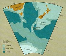
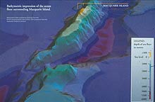
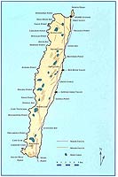
Macquarie Island is a national park and is managed by the Tasmanian Parks & Wildlife Service. It is approximately 34 km long and 5.5 km wide at its broadest point. You will notice all the faults, it is an "young" island and still emerging from the sea. It is rising at a rate of about 0.8 mm per year.

Since 1948 there has been an Australian National Antarctic Research Expedition base on the island, supported by the Australian Antarctic Division.

Before going ashore, we learn about the history and wildlife found on the island. We have to scrub our boots and the "feet" of our tripods with a bleach solution to kill soil borne diseases. Boots must have no soil on them. We vacuum our coat pockets and our packs to really make sure we don't accidentally leave behind any rubbish or seeds which could become weeds on the island.

The rules are strict. It is a national park and any historic artefacts are to be left exactly where they are found and nothing is to be taken from the island, not even the rocks! We travel to shore eight at a time in rubber boats called Naiads.

   Next - We leave behind the huge numbers of birds and seals and continue our journey south.

Search site


Find out about:

Macquarie Island - scientists and sealers
  Sea Ice and bergs - What is the difference?
Cape Adare - an historic hut on a windswept shoal and one or two penguins!
Possession Islands - covered with Adelie penguins
The journey home - Campbell and Auckland Islands


   Contact Web Manager © MESA 1999 - 2015
0.00000 secs   
     SpiderByte Web Design Top