The Science behind
a Marine Pollution
Incident
Paul Nelson, Manager,
Environment Protection Standards,
Marine Environment Division, AMSA
Oil and chemical spills in the marine environment can have widespread
impact and long-term consequences on wildlife, fisheries, coastal and marine
habitats, human health and livelihood, as well as on recreational resources of
coastal communities. It is vital that oil spill response agencies, such as AMSA
have access to good quality information, expertise and well-organised
decision support systems.
Science, in combination with Information Technology, plays a vital and leading
role when responding to marine pollution incidents.
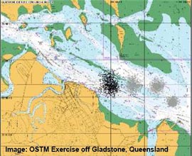
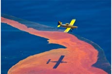
When an oil spill incident occurs, Oil Spill Trajectory Models (OSTM) are
created through a series of specialised software application tools. These are
used by AMSA as an important decision support tool to predict the movement
and behaviour of oil on the water surface, the distribution of oil in the
environment (evaporated, in the water column, on the shoreline, etc.), and to
anticipate the ultimate fate of the oil spill plume. To achieve these
calculations, the spill model relies on environmental data such as wind and
currents, physical data such as the proximity of shorelines, and chemical data
that define the properties of the oil. These models also play an integral role in contingency planning, for
backtracking mystery spills and as evidence in court for prosecutions.
OSTM outputs have been produced to assist in a number of incidents such as
the Montara Wellhead Platform (Timor Sea) in 2009 and the Shen Neng 1
(Queensland) in 2010.
Oil spills are not the only pollution threats to the marine environment. Other hazardous substances such as chemicals can also affect and damage the marine environment.
Chemical trajectory models are similar to that of OSTM, with additional functionality, reflecting the relative complexity of chemical behaviour. The model uses physical-chemical properties to predict the fate of chemicals and produces a three-dimensional model including surface, sub-surface and atmospheric outputs. |
 |
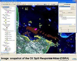
In addition to oil and chemical trajectory modelling, AMSA has developed the
Oil Spill Response Atlas (OSRA), a resource atlas based on a customised
GIS-embedded toolset and spatial database. OSRA is designed to streamline
the delivery of vital modelling, environmental, biological and logistical
information to marine spill responders during marine pollution incidents.
During a major incident, an Information Systems Coordinator ensures that the OSRA atabase is maintained up-to-date and complete, and during a major incident, provides mapping and
GIS support promptly using the OSRA and toolkit. |
 |
An Environment and An Environment and Scientific Coordinator (ESC) provides environmental and scientific advice and services to response teams during a marine pollution incident. The ESC has a background in Environmental Science and during an oil spill incident has the responsibility of interpreting and analysing the environmental and scientific data that is collected.
|
|
The main tasks of the ESC during a major incident include:
► Assessing the likely environmental effects of the spill on the environment and nearby habitats;
► Determining habitat and wildlife protection strategies;
► Shoreline Contamination Assessment and Treatment;
|
 |
► Advising on dispersant use and toxicity;
► Oil spill fate, chemistry and trajectory modelling;
► Monitoring and prediction of weather, and spill surveillance activities;
► Sampling and assessing environmental damage;
► Advising and managing of waste oil disposal;
► Cleaning and rehabilitating oiled wildlife.
The ESC assesses the ecosystem and species vulnerability or sensitivity to oil. With the assistance of GIS decision support systems, such as OSRA and Oil Spill Trajectory Models, the ESC is then able to identify nearby coastal resources and provide oil spill response eams with an accurate up-to-date assessment of the preferred environmental protection priorities that are necessary for foreshore and marine habitats that are threatened by a spill.
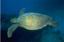
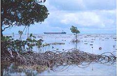
As well as oil, dispersants can themselves pose various degrees of impact on the environment, especially on highly sensitive habitats such as seagrasses, mangroves, salt marshes, corals, birds, commercial fisheries, and benthic/inter-tidal communities.
Having a sound understanding of the toxicity and effectiveness of chemical dispersants, the ESC is then able to advise on the dispersant types that should or should not be used during a spill response. |
 |
| |
|
| In addition, the ESC may also have responsibility for coordinating and managing oiled wildlife rescue, cleaning and rehabilitation with the assistance of wildlife or nature conservation agencies. |
 |
| If damage has occurred to the environment as a result of a spill, the ESC has the duty of assessing the extent and also analysing any potential short and long term impact. The mpact may be biological, physical, economic, political, or cultural loss.
References:
Applied Science Associates, Inc. (2010), OilMap User Manual Version 6.4, Rhode Island, USA.
Environment and Scientific Coordinators Training and Induction Manual, AMSA, March 2003. |
 |
|