|
|

The catchment is an area of land where all water runs to one point. It extends from the highest mountains down to the sea or it can be a small valley draining into a creek or lake. It includes the rivers, vegetation, animals, agricultural uses and even urban areas.
. 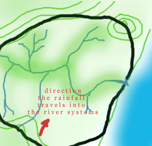
Figure1. The river starts high in the hills and runs down to the coast. If a line was drawn following the highest points which would be the top of hills, then the catchment area becomes clear.

|
|
Think about this....if you drop a plastic bag and it ends up being washed into the stormwater drains and then out to sea...what might happen. Turtles think plastic bags look like jellyfish so they try to eat them. Unfortunately the turtle usually dies after eating the plastic bag.

The catchment is diverse, that there are many different parts to it. The rivers, forests, hills, estuaries provide a variety of habitats for the animals and plants. In it they find food and shelter.